In the event of an accident or a terrorist attack that spreads radioactive material, several questions must be answered—and the sooner the better: What are the radiation levels? What are the radioactive elements and isotopes? And most importantly, exactly which areas are affected?
A mobile radiation monitoring system developed by a team of UGA scientists can help first responders answer those questions quickly along both roads and rail lines. By linking with global positioning system satellites, the system also creates a real-time map of the affected areas, allowing first responders to immediately identify dangerous areas.
With two sites in South Carolina near Augusta vying for a federal reprocessing initiative that would bring truckloads of nuclear waste through Georgia, the need for the system becomes even more timely.
“Most radioactive waste is transferred either by rail or road,” said John Noakes, UGA Center for Applied Isotope Studies director, who developed the system with associate director Glenn Murphy. “And, indeed, if there was a radioactive incident along either one of those transportation routes, those areas would have to be quickly monitored and evaluated. We knew that a system like this was needed and that we could design and build it.”
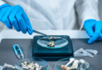
The system uses two detectors, each about 4 inches by 4 inches by 14 inches, inside a truck that is equipped for both roads and rails. The detectors are made of crystalline sodium iodide that emits light when it comes into contact with radioactive gamma rays. The scientists can identify the radioactive element, its specific isotope and its level by measuring the intensity of the emitted light.
Sodium iodide detectors have been used for more than 40 years, but linking the detector to GPS data is a relatively new development that allows for the continuous acquisition of data.
“We can map levels literally as we drive,” Murphy said. “In the past what you’d do is go to a location, stop, take the measurements and then move to the next point. Now we can take measurements continually and store the data and position.”
The current detector evolved from an earlier project in which Noakes created a similar device for mapping naturally occurring radiation along the seafloor. While brainstorming ideas, he and Murphy realized that they could adapt the aquatic system for use on land.
“We said, ‘If it can be done on the seafloor, then we can certainly do it on land,’” Murphy said. “We don’t have to make it waterproof or anything like that.”
The researchers contacted local rail line owner and operator B.R. Anderson, president of Hartwell Railroad, for permission to do a feasibility study along the line that runs through campus. In addition to granting permission to the researchers, he also donated a truck equipped for roads and rails that can be used for their research as well as in emergencies. The researchers have tested the system and demonstrated that it works, and are now exploring the possibility of adding an additional larger but less expensive detector made of plastic that will allow them to monitor radiation at higher speeds, since the current system is limited to approximately 30 miles per hour.
And although they continue to refine the system, the researchers said it has performed well and is available in the event in of an emergency. They’ve already met with the Georgia Emergency Management Agency to offer their services. “If something were to happen within the state and GEMA were to call, we could use it right now,” Murphy said. “It’s usable as we speak.”